Tuesday, July 6, 2021

East Troublesome Fire Recovery Late June 2021

 The East Troublesome fire started on October 14th, 2020 northeast of Kimmerling, Colorado in the Arapaho National Forest.  The cause of the fire is still being investigated, but this fire became the 2nd most damaging wildfire in Colorado history. The fire claimed a total of 192,457 acres.  Due to low humidity, high winds (the worst day had gusts up to 60 mph), and fallen trees due to beetle infestation, the fire grew 120,000 acres in one day. making it the most rapid-fire expansion in state history.  

Arapaho National Park is still closed and they are currently in a recovery mode called the Emergency Stabilization-Burned Area Emergency Response (BAER).  This is where they will limit the run-off, soil erosion, and protect threatened species' environment.

 The fire nearly made it to the eastern side of Estes Park and to the eastern suburbs of Grand Lake.  Two people died in the Troublesome fire that refused to evacuate.  The fire was brought under control due to a winter storm that hit the area, increasing moisture in the area, cold weather, and lower winds.  Winter conditions greatly slowed the fire and it was 72% contained by November 19th.  By Thanksgiving of last year, the fire was not a threat to any communities.  In the end, over 400 houses and structures were destroyed.

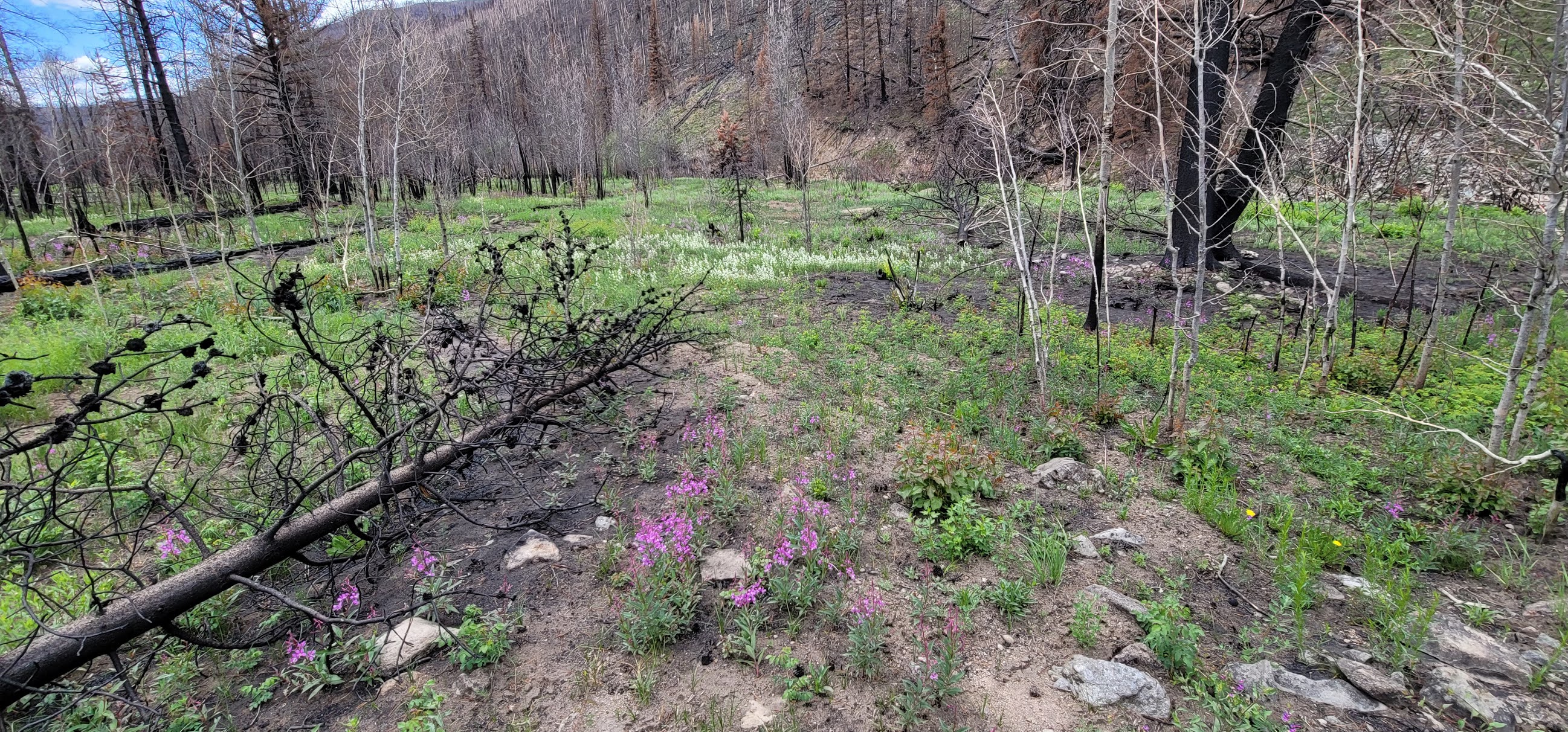
While in Colorado we drove up Co-125 and documented what it looks like now.   While walking around, I found a pile of ashes that looked nearly identical to the soil, except there was no strength to it and my foot sunk down into the hole they covered. 

From https://www.cpr.org/2021/01/25/colorados-east-troublesome-wildfire-may-signal-a-new-era-of-big-fire-blow-ups/


Sorry for the long post.  

Citations 

https://coloradoencyclopedia.org/article/east-troublesome-fire

https://www.cpr.org/2021/01/25/colorados-east-troublesome-wildfire-may-signal-a-new-era-of-big-fire-blow-ups/

https://inciweb.nwcg.gov/incident/7242/


Fireworks

 Not too much weather to report on. A heavy storm hit a couple of weeks ago, but nothing else.  Found out my phone has super-slow motion, so here are some fireworks.


Friday, May 28, 2021

May 26th, 2021 tornado and storms

 A warm front draped along northern Kansas.  Lots of moisture hung around and the combination of the two caused severe storms to fire up western and central Kansas.  For several days the storm outlook talked about an energetic high atmosphere that promised large to giant-sized hail.  What interested me was the increase to 15% in the late afternoon convective outlook.  Deep layer shear (winds twisting with height) and increasing lower-level winds increased the tornado probability.

Due to school getting ready to be let out for the Summer, I had a rather late start.  The storms had already fired near Russel and a tornado had hit near Holyrood.  I decided to drive up to Lindsborg and go out west.  The storms were slow-moving only moving around 20-25 mph.  I made it to Kanopolis Lake and thought we were seeing funnels in the storm. 


The intense cloud-to-ground lightning started a couple fires.  The wall cloud did not produce anything and this storm ran out of power being cannibalized by a stronger storm to the west.  

Being near Kanopolis Lake, we dropped in to get a couple photos near the water as the storm threatened to squall out.

My daughter grabbed the next couple of photos.


I ran down to the peer as the wind started to hit the lake.


We left the lake and headed to the brim of the lake.  Between lightning, we ran up and shot some quick shots.  

We ran to Geneseo as the 2nd storm was beginning to power up.  We dove south on K-14 and I started to see dust bloom.  We drove quickly as my daughter began shooting.  I saw the dust, but wasn't aware of the tornado until we drove past the dust.  I was able to get quickly past the spot and saw the funnel.  The national weather service said the tornado was only on the ground a 1/4 mile and rated it as an EF0.


We ended up a little closer to it than I wanted to be but quickly got south of the storm.  


We continued south through Lyons as the storm moved a little more southernly.  The town sounded their tornado sirens and we stopped at a couple places for a quick bite.  Most of the people were a little too freaked out by the sirens to give us food.  We went further south and watched the storm start to fall a part.  A lot of odd things happening where it looked like it was falling into a squal line.  Then condense into a wall cloud, then everything softened and fell apart.  We gave up on the storms and headed back towards town.  Ultimately it was a very busy weather day that ended the tornado drought

The end of May is here and we are probably going to start warming up quickly.  Chase season will probably be moving on soon.  As a note.  I recently started using my new phone for photos and have been pleasantly surprised with how well they have come out.  

Sunday, May 9, 2021

Storms May 8th, 2021

 Seems like the last several years, I always start my first blog of the year saying it's been a slow year.  It's been cooler, dry, ridges in the wrong place, but we've had some rain.  A frontal boundary set up some action for Kansas and it being a Saturday, I was able to chase.


They upgraded the convective outlook from slight to enhanced and the stage was set for north-central Kansas.    My daughter and I headed to Wilson, Kansas and hung out at Wilson Lake until the storms started to initiate.


We moved back to town and closer to I-70 to head toward any interesting popups.  The storms initiated and we had a good candidate to the east of us.  We headed toward Russel and pulled off in a couple of small towns to watch.


The storms were quickly showing mammatus clouds.
The storms went severe and we moved south out of Russel and followed.  One storm split, then absorbed another storm and became strong.

We stayed between two of the severe storms watching a couple areas of interest.

Down near Otis, Kansas, we started to see wall clouds forming.
A clear slot opened near the wall cloud, but nothing developed.
We started seeing good hail shafts coming out of the storm, and soon the dryline had crossed over limiting a lot of the severe potential and cutting the fuel from the storms.

The clouds started to fall apart and the storms more to the east became larger and more powerful.  

My daughter captured some great Meadowlarks and thunder, so I recorded this.  Please turn on the sound otherwise, it's a fairly boring video.


We headed back east with the storms decently ahead of us.  We stopped a couple times to capture some lightning and I may post those videos or captures later.  We started the long trek home with an incredible lightning show to the north and east of our location.  We made it home in time to see Saline County under a tornado warning, but only a funnel was spotted and at this time, there was no damage reported.

Hopefully we will see more storms this year, otherwise it's been fairly quiet.


Monday, June 22, 2020

June 21st, 2020 Severe Thunderstorm

It's been an unbelievably quiet season this year.  We've seen the summer weather pattern (Omega Block Pattern) come in bringing the temperature up and essentially stopping the chance of severe weather in the plains.
A cold front draped north of the Kansas/Nebraska line and a dry line came in from the Kansas/Colorado border.  This gave us an avocado shaped convective outlook with a moderate risk which I think was the first moderate risk for Kansas this year.  I also believe we have not had any tornado watches in Kansas this year as well.  Due to the moderate risk we were eyeing Dodge City but as we left noticed a tornado warning up north caused by a landspout near Hoxie, Kansas.  

We were unaware of it just being a landspout and were drawn to this warning area.  We left heading up to the McPherson area before any storms had formed on the dryline.  For some reason, I have always been drawn to cold fronts although they tend to have low outcomes for tornadoes.  Plus, I figured we could shoot west quickly if needed.

We got into cloud cover quickly and found some Mammatus clouds


We finally made it to the storm we wanted.  The storms along the dryline had started to fire.
 The entire storm rotated as seen in the youtube video
We had a family stop us and ask if it was coming toward us.  At the time it was mostly stationary but I mentioned that can change quickly, and it did,  The storm started moving south as the cold front moved.
 We did have to change location as a hail core was evident on radar.  They had reports of 3.5 inch hail from the storm but I did not see any.  The storm itself started falling apart but continued the hailcore and we decided to go west to catch the dryline.  After seeing reports that it wasn't doing anything and seeing that it was becoming a squall line, we decided to head home.
 Quick panoramic grab with my phone.

We made it home about an hour before the storm hit.  It seemed to slow down and reorganized.  We were briefly under a severe thunderstorm warning in Sedgwick County, but that was canceled as the southern parts of the squall powered up and had a brief tornado warning in Oklahoma  We ended with a fairly gentle rain and thunder.


Wednesday, May 13, 2020

Slow beginning to the season

It's been slow which seems to be a more common post I make every April and May.  There have been no confirmed tornados this year in the state of Kansas as of May 10, 2020 but that may change in the coming week.  We've had nice weather, but the jetstream hasn't been in it's normal form, where it generally dives over Kansas, allowing gulf moisture in.  This year it's blocked it from Kansas and we've been rather cold.  Most storm this year have been in Texas, Louisiana, and the rest of Dixie Alley.  A surprise shift may change that for next week as local severe storms have been forecast Wednesday into Saturday.

On Thursday this last week, a group of storms moved through the area.  These were below severe limits but produces a nice shelf cloud and lots of instant cloud to ground lightning.  


I also created a video of slow-motion video lightning strikes.


Sunday, April 12, 2020

April 11th, 2020 severe storms

It's been a slow strange year.  We had early storms form in March with tornado outbreaks in Tennessee, the emergence of the Covid 19 pandemic, and just all the weirdness of the world we are in.  I figured we would have an earlyorm season emerging and I could go chase to my heart's content.  Then the state shut down, we entered the world of online working, teaching, and learning.
I started a project documenting how the shutdown is affecting Wichita, shooting some of the businesses that have succumbed to closing due to the stay at home orders.

Storm chasing has been a little questionable with local sheriffs requesting people from heavily affected areas not coming to the area for fear that someone could spread the virus.  The two main population centers in Kansas, Wichita, and Kansas City have around 1000 cases.  The fear is that many cases are not being tested or being known.

In this time of shutdown, I am teaching, some days a lot.  I'm also trying to keep busy and get creative with my drone, photography, videography, and I recently started my third novel.  I will be starting a section called #Covidcoverage where I document what's going on.

As of what happened yesterday, simple term, cold front.  Yesterday we made it to 83 degrees, today its 36 degrees with winds gusting to 60mph.  As I write this, there is a tornado outbreak in Dixie Alley.  We are under a high wind warning and freeze warning for April 12th, but at least there are no tornado emergencies.

Yesterday, we had a slight chance of severe weather with some pop-ups along the cold front/dry line mix that came down from the north.  I didn't have much hope that we would have much but the HRRR was looking promising to the north and east of Wichita.  Around 5pm a pop up grew and I wanted a chase.  We went north out to Newton, Kansas and recorded a supercell while it was producing  above quarter-sized hail in Walton.

This storm was gorgeous, bright white, and rotating like a skater.  I didn't have all my gear with me but attempted to do a time-lapse.  Needless to say, heavy wind made it difficult.  This is something I've seen done before, most notibly by Stephen Locke when he chased.  The wind was to heavy for drone or tri-pod so I did what I could with handheld and this was the outcome:


Here were some of the photos


This was an odd storm that fell apart to the east. I love the ribbon of cloud left of center.

Radar Loop from storm from the National Weather Service

Satellite loop from the storm from the National Weather Service
3D image of storm showing core extending above 40,000 feet