We ended up having the third wettest June. 11.5 inches roughly fell in the area getting Cheney Reservoir back to near normal levels.
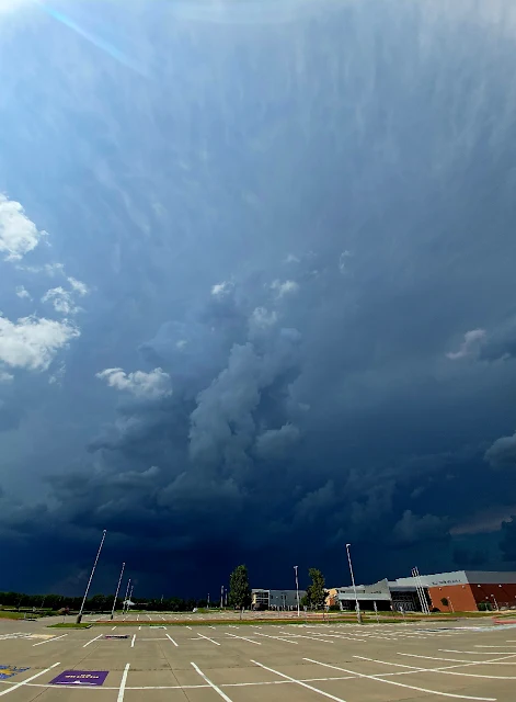
We had a slight risk for storms and a storm developed north of town. I wouldn't have known except I got a call from a friend wondering if it was safe to drive through. It was a slow moving summer pop up with some high tops on it and seemed very dark.
The storm powered up and the local NWS issues a severe thunderstorm warning for hail and high wind.
The wonky panoramic showed the anvil directly overhead.
The thunder was constant in this storm and showed areas of very heavy rain.
There was a couple of areas of interest but nothing panned out.
I did just get the window replaced on the car and didn't want to chance much so I felt before it hit.
This is about two minutes of the soundscape, birds and thunder.
I always start the storm season with . . . It's been a slow year.
Went out noticing a few severe warned supercells nearby. Wasn't ready to see this monster outside of town. Awesome structure, missed us, and didn't produce much other than hail.
There seemed to be some odd rotation on the north end of the storm and I didn't take many screenshots of radar.
Katie Parks was a little closer to the storm and took this from her back yard.
This was taken by Ruminator Sam at the Maize Baseball fields.
We will see what the rest of the season brings. Looks like rain this week and we need it. I miss clouds.
It's been a slow strange year. We had early storms form in March with tornado outbreaks in Tennessee, the emergence of the Covid 19 pandemic, and just all the weirdness of the world we are in. I figured we would have an earlyorm season emerging and I could go chase to my heart's content. Then the state shut down, we entered the world of online working, teaching, and learning.
I started a project documenting how the shutdown is affecting Wichita, shooting some of the businesses that have succumbed to closing due to the stay at home orders.
Storm chasing has been a little questionable with local sheriffs requesting people from heavily affected areas not coming to the area for fear that someone could spread the virus. The two main population centers in Kansas, Wichita, and Kansas City have around 1000 cases. The fear is that many cases are not being tested or being known.
In this time of shutdown, I am teaching, some days a lot. I'm also trying to keep busy and get creative with my drone, photography, videography, and I recently started my third novel. I will be starting a section called #Covidcoverage where I document what's going on.
As of what happened yesterday, simple term, cold front. Yesterday we made it to 83 degrees, today its 36 degrees with winds gusting to 60mph. As I write this, there is a tornado outbreak in Dixie Alley. We are under a high wind warning and freeze warning for April 12th, but at least there are no tornado emergencies.
Yesterday, we had a slight chance of severe weather with some pop-ups along the cold front/dry line mix that came down from the north. I didn't have much hope that we would have much but the HRRR was looking promising to the north and east of Wichita. Around 5pm a pop up grew and I wanted a chase. We went north out to Newton, Kansas and recorded a supercell while it was producing above quarter-sized hail in Walton.
This storm was gorgeous, bright white, and rotating like a skater. I didn't have all my gear with me but attempted to do a time-lapse. Needless to say, heavy wind made it difficult. This is something I've seen done before, most notibly by Stephen Locke when he chased. The wind was to heavy for drone or tri-pod so I did what I could with handheld and this was the outcome:
Here were some of the photos
This was an odd storm that fell apart to the east. I love the ribbon of cloud left of center.
Radar Loop from storm from the National Weather Service
Satellite loop from the storm from the National Weather Service
3D image of storm showing core extending above 40,000 feet
It was a beautiful night for Wingnuts baseball in Wichita. Cool 80's for late June, a crisp occasional wind, and big storms that blew to the north and east of us, then the dreaded rain delay. Odd thing was this was the second time that I got soaked shoes in that day. Special shout out to Gunner. Hope you are feeling better.
Blame Ming!
Lots of lightning to the east as that storm, which caused a tornado in Salina and damage in Butler Co. kept pulsing.
Is second season starting early? A cold front and dry line combo moved into the Wichita area with high winds, hail, and an area of rotation that quickly became rainwrapped in the dark and caused some fear that a tornado had touched down north of Wichita. High winds caused damage to Maize, Bel Aire, and Valley Center areas and at one point left 8,000 without power.
Sunrise in Valley Center
Storms off to the west in Kingman Co.
Non rotating SCUD or scary looking clouds
inflow feeding the storm
The storm hitting Maize with high winds. Look for the face in the clouds and the hand reaching out.
It's been a while since I captured a nice shelf cloud coming into the Wichita area. It set up on a nice cold front that swept into the Wichita area. . .
From the NWS Wichita Website:
Radar animation
Velocity animation
The first picture was taken up near Newton. Not real spectacular, a bit of a blob. Maybe a hint of a shelf forming in the lower right hand corner. I relied on radar data and the storm looked to gain a nice bow echo, so I headed back to the Valley Center area (north of Wichita).
Taken from Galaxy S5, a small fire is seen right of center. This was non-storm related.
The shelf cloud had developed well and was approaching quickly. I found an open area facing north and west, (the road goes east and west).
Early reports had baseball sized hail out near Kingman and 80 mph winds.
I was beginning to see the gust front, so I headed home before the main winds hit. Although not too bad of winds were recorded in Valley Center, a wind gust in NE Wichita was recorded at 78 mph.