Thursday, July 10, 2025

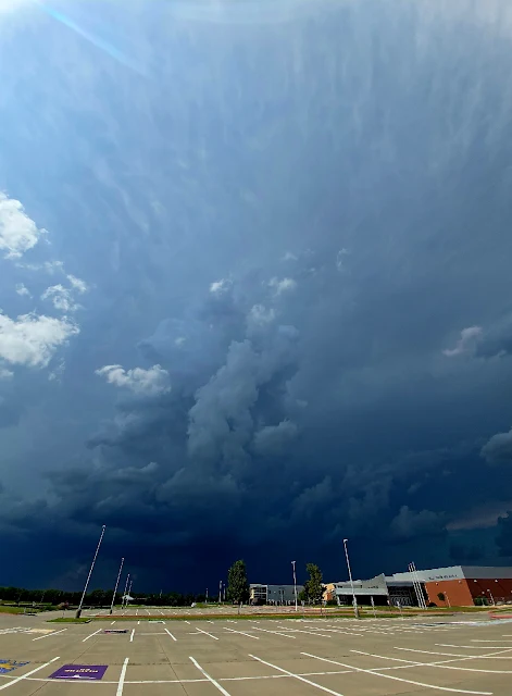
July 8th Severe Warned Storm

We ended up having the third wettest June. 11.5 inches roughly fell in the area getting Cheney Reservoir back to near normal levels. 

We had a slight risk for storms and a storm developed north of town. I wouldn't have known except I got a call from a friend wondering if it was safe to drive through. It was a slow moving summer pop up with some high tops on it and seemed very dark.

The storm powered up and the local NWS issues a severe thunderstorm warning for hail and high wind. 
The wonky panoramic showed the anvil directly overhead.

The thunder was constant in this storm and showed areas of very heavy rain. 
There was a couple of areas of interest but nothing panned out.
I did just get the window replaced on the car and didn't want to chance much so I felt before it hit.


This is about two minutes of the soundscape, birds and thunder.


Thursday, June 19, 2025

Severe storms June 17th

 It's been a wet June.  All the spring rains seem to have come this month with a 5.5 inch day on June 3rd and 4th which caused significant flooding in my area.


Then this group of storms that hit, not once, not twice, but with three severe storms on June 17th. We were without power for 36 hours and have possibly lost two of our large trees.

This was the beginning of the wind.  Eisenhower Airport recorded a 102 mph wind gust 


The moment power went out in the area.
This was the main storm that caused damage in the area.  

Interesting enough, this was not the storm heavily warned about.  This was a derecho that came down from Nebraska.  There was another storm system that could cause more damage.

A little weather trough pushed by the previous storm's outflow gave a moderate area for storms.
I was on tree cleanup most of the day but around 5pm decided to run up to Newton to see an area that was developing.  An area near Wichita was coming in but a storm down south looked like it strengthened.


Harper, Kansas had a breif tornado 1 mile SSW of the city but I was a little late getting into the area.
This was on the back end of the storm.  Not sure if it was a microburst (strong winds were in the area) or a hail foot.
It dissipated quickly, and formed some fog from the area.  

An odd starship looking storm to the west looked interesting.

The air had cooled but it had a good groundscrubber with it.

Lots of positive stroke lightning out of both storms.  They seemed to pulse and look like they were getting their act together but neither produced.

One of the local guys stopped to see if I needed help, but recommended The Red Rooster Cafe in Harper for a good bite to eat.

The storm started to fall apart but found a great spot with birds chirping, but the cows were not having this storm nonsense. I would like to introduce the storm cows.


Wednesday, April 23, 2025

Storms April 22, 2025

I always start the storm season with . . . It's been a slow year. 

Went out noticing a few severe warned supercells nearby. Wasn't ready to see this monster outside of town. Awesome structure, missed us, and didn't produce much other than hail. 

There seemed to be some odd rotation on the north end of the storm and I didn't take many screenshots of radar.


Katie Parks was a little closer to the storm and took this from her back yard.


This was taken by Ruminator Sam at the Maize Baseball fields.
We will see what the rest of the season brings. Looks like rain this week and we need it.  I miss clouds.

Monday, October 28, 2024

Got a Little Rain

We went from not only a record breaking day temperature wise but one of the hottest days in Fall on Thursday, October 24th with 93 degrees. I'm tired of the heat and ready for crockpot weather.

We did have a cold front that knocked us down to regular temps. No severe weather but a nice linear storm developed off the fronts allowing some lightning photos with yes, my skully. I have a 12 foot skeleton that may be up for a while.


Today is supposed to be 88, old record is 83. Storms and high wind on the horizon.