It's been a slow year but last night lucked into an incredible fireworks show. Hosted by the National Fireworks Association (NFA), This was the end of their week-long convention to showcase many of the new fireworks. Needless to say, it was incredible, with the majority of the show displaying new fireworks. The finale was great but also lead to another show directly after. We left a very packed park not long after the second show started already watching two very full hours of fireworks. Here were some of my favorite photos. Finale video is at the end.
Saturday, September 15, 2018
Fireworks 09/14/2018
It's been a slow year but last night lucked into an incredible fireworks show. Hosted by the National Fireworks Association (NFA), This was the end of their week-long convention to showcase many of the new fireworks. Needless to say, it was incredible, with the majority of the show displaying new fireworks. The finale was great but also lead to another show directly after. We left a very packed park not long after the second show started already watching two very full hours of fireworks. Here were some of my favorite photos. Finale video is at the end.
Labels:
4th of July,
boom,
Fire,
Firework shows,
Fireworks
Saturday, July 14, 2018
lightning 07/13/2018
A simple cold front moved into the area destabilizing the atmosphere enough for some evening showers. It was already Drench-your-shirt humid. Luckily it rained most of the late night.
My oldest daughter and I did an ice cream run and found this wall cloud to the west of the city.
We ran home, grabbed our cameras and went Northwest of the city. Lots of active lightning at first, then it slowed down as the storm lost its punch.
Same bolt, two frames.
My oldest daughter and I did an ice cream run and found this wall cloud to the west of the city.
Same bolt, two frames.
Labels:
lightning,
positive stroke lightning.,
storm,
thunder,
thunderstorm
Wednesday, July 4, 2018
Severe Weather 06/26/2018
Summer had set on Wichita or at least we seemed to be in for a long, hot, dry days. Little patches of rain happened occasionally, but not enough to knock off the severe drought that had lingered.
After the initial warnings and not seeing tornadoes I moved to near Rose Hill but unfortunately went though Andover which really slowed me down after they had some initial wind damage.
There had been some storms in the morning that provided a couple of quick thunderstorm warnings, but nothing too strong. Most of the storms dissipated just before hitting Wichita to reform after and produce stronger storms. I had gone out in the morning just to try to shoot more photography.
Storms looked to be focused mainly on the Kansas/Missouri border and I thought the less than spectacular morning storms may be the end of it. The five o'clock News mentioned that there was a stationary front just to our west that may form storms in the next few hours. By six, a number of storms formed NE of Wichita and slowly moved to the SE. Within 30 minutes from that, the storms had become tornado warned.
After the initial warnings and not seeing tornadoes I moved to near Rose Hill but unfortunately went though Andover which really slowed me down after they had some initial wind damage.
Labels:
06/26/2018 storms,
clouds,
EF0,
El Dorado,
near El Dorado,
scary clouds,
storm,
storms,
thuderstorms,
tornado
Wednesday, June 27, 2018
Local Church hit by Lightning
On June 24th, in the wee hours of the morning, lightning struck St. Joseph Catholic Church in Andale. Damage is thought to be around one million dollars. Clean up is currently underway.
Tuesday, May 29, 2018
Saturday, May 26, 2018
It's been slow
May 1st opened up with the latest tornado season in a long time. Late may is already threatening summer weather patterns. SO the last few weeks while closing down the classroom season, I've been chasing when I can. Sometimes it's just pretty clouds.


This next set was a small front driven squall line that was going back and forth on being severe. The tops of the storms were illuminated in moonlight:


This next set was a small front driven squall line that was going back and forth on being severe. The tops of the storms were illuminated in moonlight:
Wednesday, May 2, 2018
Storms 050118 May Day
This has been an interesting year. Although Spring supposedly started in March, think someone ignored the calendar. We have been in a long drought, broken up by an occasional cloud dropping less than a tenth of an inch of precipitation. We even had a brief snow as late as April 14th.
Our first hope came April 21st where we had a little over an inch of rain.
Rain would set out on the 7-10 day forecast at least 6 days out, then would disappear as it came closer. Then May 1st came into view. A slight risk slowly evolved. A tornado threat also appeared.

I watched the storms blow up the I70 highway.As they approached the I35 exchange I decided to run up north to see the storms.
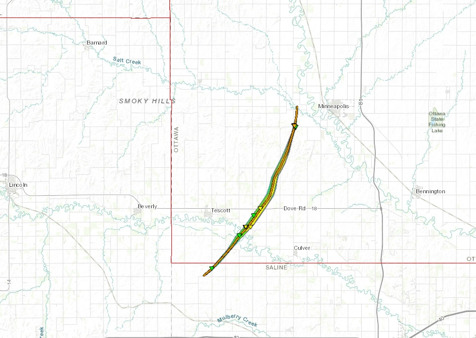
This I believe is when the storm was hitting Tescott,
I watched the ground scrubbers off in the distance in the failing light. They were down mudsoaked roads and out of touch. I started to head back to I35 but a wreck and several power poles diverted me to other wet dirt and clay roads for a fun run back to the highway and a long drive home. The storms provided quite the light show as I drove off with almost constant lightning. I wished I could have pulled over and watched for a while, but I had an early morning the next day and would get home late enough.
Subscribe to:
Comments (Atom)


