We ended up having the third wettest June. 11.5 inches roughly fell in the area getting Cheney Reservoir back to near normal levels.
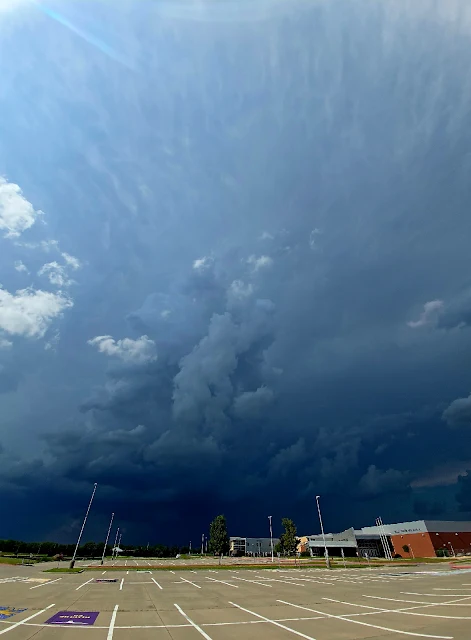
We had a slight risk for storms and a storm developed north of town. I wouldn't have known except I got a call from a friend wondering if it was safe to drive through. It was a slow moving summer pop up with some high tops on it and seemed very dark.
The storm powered up and the local NWS issues a severe thunderstorm warning for hail and high wind.
The wonky panoramic showed the anvil directly overhead.
The thunder was constant in this storm and showed areas of very heavy rain.
There was a couple of areas of interest but nothing panned out.
I did just get the window replaced on the car and didn't want to chance much so I felt before it hit.
This is about two minutes of the soundscape, birds and thunder.
It's been an unbelievably quiet season this year. We've seen the summer weather pattern (Omega Block Pattern) come in bringing the temperature up and essentially stopping the chance of severe weather in the plains.
A cold front draped north of the Kansas/Nebraska line and a dry line came in from the Kansas/Colorado border. This gave us an avocado shaped convective outlook with a moderate risk which I think was the first moderate risk for Kansas this year. I also believe we have not had any tornado watches in Kansas this year as well. Due to the moderate risk we were eyeing Dodge City but as we left noticed a tornado warning up north caused by a landspout near Hoxie, Kansas.
We were unaware of it just being a landspout and were drawn to this warning area. We left heading up to the McPherson area before any storms had formed on the dryline. For some reason, I have always been drawn to cold fronts although they tend to have low outcomes for tornadoes. Plus, I figured we could shoot west quickly if needed.
We got into cloud cover quickly and found some Mammatus clouds
We finally made it to the storm we wanted. The storms along the dryline had started to fire.
The entire storm rotated as seen in the youtube video
We had a family stop us and ask if it was coming toward us. At the time it was mostly stationary but I mentioned that can change quickly, and it did, The storm started moving south as the cold front moved.
We did have to change location as a hail core was evident on radar. They had reports of 3.5 inch hail from the storm but I did not see any. The storm itself started falling apart but continued the hailcore and we decided to go west to catch the dryline. After seeing reports that it wasn't doing anything and seeing that it was becoming a squall line, we decided to head home.
Quick panoramic grab with my phone.
We made it home about an hour before the storm hit. It seemed to slow down and reorganized. We were briefly under a severe thunderstorm warning in Sedgwick County, but that was canceled as the southern parts of the squall powered up and had a brief tornado warning in Oklahoma We ended with a fairly gentle rain and thunder.
A simple cold front moved into the area destabilizing the atmosphere enough for some evening showers. It was already Drench-your-shirt humid. Luckily it rained most of the late night.
My oldest daughter and I did an ice cream run and found this wall cloud to the west of the city.
We ran home, grabbed our cameras and went Northwest of the city. Lots of active lightning at first, then it slowed down as the storm lost its punch.
It's been another dry season. We will take the rain when we can get it. One previous band moved through with a lot of lightning and while heading home from an event, saw this storm building to the NW and stealing a lot of power from the previous line. A small cold front moved though the area triggering the rain.
The storm started with a lot of lightning then suddenly died off. These were located out between Hutchinson and Lindsborg around 10:30PM and were non-severe storms.
Ribbon of light cause by cars passing on Oliver.
Central storm. Another developed along side it.
First nighttime pano. 30 second exposure, lights are from Valley Center.
Lots of cloud to cloud lightning, this was one of the few cloud to ground (CG) strikes.
Another CG strike
I wish I had this light trail with the previous CG strike. I could Photoshop but have always been against Photoshoping unless it's basic adjusting.
Lat two days were 111 degrees. Today 106. I think we've received 0.11" of rain this month. Corn is already being harvested to cut losses and let farmers break even. Until we get rain we can only dream of thunder. I found this last evening while working on server issues. I'm not a tech guy, but it gave me time to surf old photo files and see some things I hadn't posted. This storm was a nice electrical one from May 30th, 2012. Brown haze on clouds are city lights from Wichita.